
Dour topographic map
Interactive map
Click on the map to display elevation.
About this map
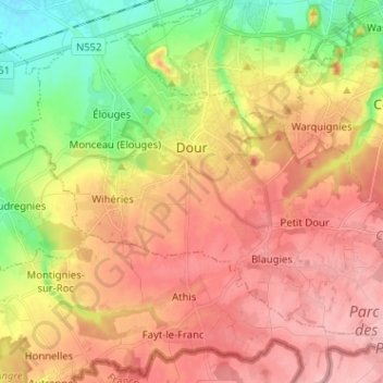
Name: Dour topographic map, elevation, terrain.
Location: Dour, Mons, Hainaut, Wallonia, 7370, Belgium (50.35319 3.72501 50.42062 3.85254)
Average elevation: 308 ft
Minimum elevation: 72 ft
Maximum elevation: 489 ft
Other topographic maps
Click on a map to view its topography, its elevation and its terrain.
Saint-Ghislain
Saint-Ghislain, Mons, Hainaut, Wallonia, Belgium
Average elevation: 177 ft
Colfontaine
Colfontaine, Mons, Hainaut, Wallonia, 7340, Belgium
Average elevation: 299 ft