
La Haine topographic map
Interactive map
Click on the map to display elevation.
About this map
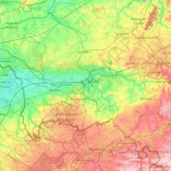
Name: La Haine topographic map, elevation, terrain.
Location: La Haine, Mons, Hainaut, Wallonia, Belgium (50.40742 3.58891 50.48099 4.28183)
Average elevation: 315 ft
Minimum elevation: 30 ft
Maximum elevation: 774 ft
Other topographic maps
Click on a map to view its topography, its elevation and its terrain.
Saint-Ghislain
Saint-Ghislain, Mons, Hainaut, Wallonia, Belgium
Average elevation: 177 ft
Colfontaine
Colfontaine, Mons, Hainaut, Wallonia, 7340, Belgium
Average elevation: 299 ft