
Yawning Glacier topographic map
Interactive map
Click on the map to display elevation.
About this map
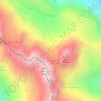
Name: Yawning Glacier topographic map, elevation, terrain.
Average elevation: 5,617 ft
Minimum elevation: 3,176 ft
Maximum elevation: 7,582 ft
Other topographic maps
Click on a map to view its topography, its elevation and its terrain.
Gifford Pinchot National Forest
Gifford Pinchot National Forest, National Forest Development Road 9341, Skamania County, Washington, USA
Average elevation: 2,638 ft
Magnolia
USA > Washington > Seattle
Magnolia, Seattle, King County, Washington, 98199, USA
Average elevation: 171 ft
Duwamish River
Duwamish River, King County, Washington, 98178, USA
Average elevation: 177 ft
Olympic Mountains
Olympic Mountains, Jefferson County, Washington, 98305, USA
Average elevation: 1,677 ft
Cougar Mountain Regional Wildland Park
USA > Washington > Coal Creek
Cougar Mountain Regional Wildland Park, Coal Creek, King County, Washington, USA
Average elevation: 873 ft
Sehome Hill Arboretum
USA > Washington > Bellingham
Sehome Hill Arboretum, Arboretum Drive, Happy Valley, Bellingham, Whatcom County, Washington, 98225-8225, USA
Average elevation: 236 ft
Lake Union Park
USA > Washington > Seattle
Lake Union Park, 860, Belltown, Seattle, King County, Washington, 98109, USA
Average elevation: 174 ft
Willapa Hills Trail
USA > Washington > Ceres
Willapa Hills Trail, Ceres, Lewis County, Washington, USA
Average elevation: 679 ft
Carkeek Park
USA > Washington > Seattle
Carkeek Park, 950, Broadview, Seattle, King County, Washington, 98177, USA
Average elevation: 210 ft
Brooklyn
USA > Washington > Brooklyn
Brooklyn, Pacific County, Washington, USA
Average elevation: 344 ft
American River
American River, Yakima County, Washington, USA
Average elevation: 4,501 ft
Gas Works Park
USA > Washington > Seattle
Gas Works Park, 2101, Eastlake, Wallingford, Seattle, King County, Washington, 98103, USA
Average elevation: 125 ft
L. T. Murray Wildlife Area (Whiskey Dick Unit)
L. T. Murray Wildlife Area (Whiskey Dick Unit), Vantage Highway, Kittitas County, Washington, USA
Average elevation: 1,768 ft
Fort Steilacoom Park
USA > Washington > Lakewood
Fort Steilacoom Park, The Meadows At Oakbrook, Lakewood, Pierce County, Washington, USA
Average elevation: 256 ft
Banks Lake
Banks Lake, Coulee Corridor, Grant County, Washington, USA
Average elevation: 2,126 ft
Diablo Lake
USA > Washington > Diablo
Diablo Lake, North Cascades Highway, Diablo, Whatcom County, Washington, USA
Average elevation: 2,110 ft
Mount Pilchuck
Mount Pilchuck, Snohomish County, Washington, USA
Average elevation: 3,711 ft
Dash Point State Park
USA > Washington > Federal Way
Dash Point State Park, Twin Lakes, Federal Way, King County, Washington, USA
Average elevation: 246 ft
Commencement Bay
USA > Washington > Browns Point
Commencement Bay, Klapache Avenue Northeast, Browns Point, Pierce County, Washington, 98418, USA
Average elevation: 3 ft
Lake Wallula
USA > Washington > Yellepit
Lake Wallula, Ayers Road, Yellepit, Benton County, Washington, 99363, USA
Average elevation: 883 ft
Osborne
USA > Washington > Osborne
Osborne, Grant County, Washington, 99123, USA
Average elevation: 1,791 ft
KONA-AM (Kennewick-Richland-Pasco)
KONA-AM (Kennewick-Richland-Pasco), South 2047 Pr Southeast, Finley, Benton County, Washington, USA
Average elevation: 361 ft
Moore (site)
USA > Washington > Moore (site)
Moore (site), Chelan County, Washington, USA
Average elevation: 1,880 ft
First Hill
USA > Washington > Mercer Island
First Hill, Mercer Island, King County, Washington, 98040, USA
Average elevation: 102 ft
Teal Duck Slough Dam
Teal Duck Slough Dam, Pacific County, Washington, 98590, USA
Average elevation: 95 ft
Dewey
USA > Washington > Dewey
Dewey, Whatcom County, Washington, 98226, USA
Average elevation: 299 ft
McMicken Island
McMicken Island, Mason County, Washington, USA
Average elevation: 52 ft
East Port Orchard
USA > Washington > East Port Orchard
East Port Orchard, Kitsap County, Washington, 98366, USA
Average elevation: 226 ft
Huffman Peak
Huffman Peak, Skamania County, Washington, USA
Average elevation: 3,061 ft
Hanford Reach National Monument
USA > Washington > Pearl
Hanford Reach National Monument, Route 4 North, Pearl, Benton County, Washington, USA
Average elevation: 1,243 ft
Nisqually River
Nisqually River, Pierce County, Washington, USA
Average elevation: 1,309 ft
Richardson Glacier
Richardson Glacier, Chelan County, Washington, USA
Average elevation: 6,919 ft
Eldorado Glacier
Eldorado Glacier, Roush basin access trail, Skagit County, Washington, USA
Average elevation: 6,739 ft
Colonial Glacier
USA > Washington > Diablo
Colonial Glacier, Pyramid Lake Trail, Diablo, Whatcom County, Washington, USA
Average elevation: 6,060 ft
Pearrygin Lake
USA > Washington > Okanogan County
Pearrygin Lake, Pearrygin Lake Trail, Okanogan County, Washington, 98862, USA
Average elevation: 2,201 ft
Gibraltar Rock
Gibraltar Rock, Pierce County, Washington, USA
Average elevation: 11,749 ft
Merrill Lake Campground
USA > Washington > Cougar
Merrill Lake Campground, Cougar, Cowlitz County, Washington, USA
Average elevation: 2,067 ft
Mount Triumph
Mount Triumph, Whatcom County, Washington, USA
Average elevation: 5,033 ft
American Border Peak
American Border Peak, Whatcom County, Washington, USA
Average elevation: 5,505 ft
Salmo-Priest Wilderness
Salmo-Priest Wilderness, National Forest Development Road 245, Pend Oreille County, Washington, USA
Average elevation: 4,272 ft
Noisy-Diobsud Wilderness
Noisy-Diobsud Wilderness, Watson Lake boot trail, Whatcom County, Washington, USA
Average elevation: 3,602 ft
Ebeys Landing
USA > Washington > San de Fuca
Ebeys Landing, San de Fuca, Island County, Washington, 98239-0745, USA
Average elevation: 72 ft
Colonel Bob
Colonel Bob, Grays Harbor County, Washington, USA
Average elevation: 3,304 ft