Geolocate

Goldsboro topographic map

Click on the map to display elevation.

About this map

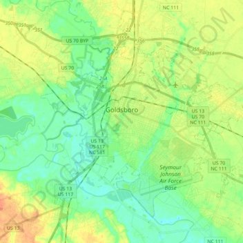
Name: Goldsboro topographic map, elevation, terrain.

Location: Goldsboro, Wayne County, North Carolina, United States (35.31243 -78.06589 35.44312 -77.89099)

Average elevation: 108 ft

Minimum elevation: 43 ft

Maximum elevation: 217 ft

Wayne County trails, hiking, mountain biking, running and outdoor activities

Other topographic maps

Click on a map to view its topography, its elevation and its terrain.

Dudley

United States > North Carolina > Wayne County

Average elevation: 174 ft

Ridgewood

United States > North Carolina > Wayne County > Goldsboro

Average elevation: 118 ft

Gear up for your next adventure:

🔦Powerful Headlamps - Ultra-bright hands-free lighting for night navigation
🔦Compact Flashlight - Reliable flashlight for emergencies
❄️Traction Cleats - Prevent slips on icy trails during winter hikes
🪶Trail Camera - Capture wildlife on your hikes
🧤Hiking Gloves - Protective gloves for rugged trails

As an Amazon Associate, this site earns from qualifying purchases at no extra cost to you.