
Xuân Lộc District topographic map
Interactive map
Click on the map to display elevation.
About this map
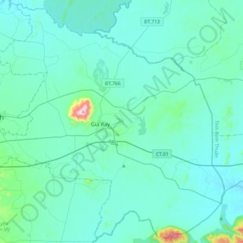
Name: Xuân Lộc District topographic map, elevation, terrain.
Location: Xuân Lộc District, Đồng Nai Province, 76615, Vietnam (10.76577 107.23803 11.08915 107.57729)
Average elevation: 404 ft
Minimum elevation: 180 ft
Maximum elevation: 2,674 ft
Other topographic maps
Click on a map to view its topography, its elevation and its terrain.
Định Quán
Vietnam > Dong Nai province > Định Quán District
Định Quán, Định Quán District, Đồng Nai Province, Vietnam
Average elevation: 463 ft
Xã Thanh Sơn
Vietnam > Dong Nai province > Định Quán District
Xã Thanh Sơn, Định Quán District, Đồng Nai Province, Vietnam
Average elevation: 410 ft
Tân Phú District
Tân Phú District, Đồng Nai Province, Vietnam
Average elevation: 610 ft
Long Thành District
Long Thành District, Đồng Nai Province, Vietnam
Average elevation: 138 ft
Trảng Dài Ward
Vietnam > Dong Nai province > Bien Hoa City
Trảng Dài Ward, Biên Hòa City, Đồng Nai Province, Vietnam
Average elevation: 105 ft
Phường Xuân Trung
Vietnam > Dong Nai province > Long Khánh City
Phường Xuân Trung, Long Khánh City, Dong Nai Province, Vietnam
Average elevation: 548 ft
Long Khánh City
Vietnam > Dong Nai province > Long Khánh City
Long Khánh City, Dong Nai Province, Vietnam
Average elevation: 528 ft
Cát Tiên National Park
Cát Tiên National Park, Tân Phú District, Dong Nai province, Vietnam
Average elevation: 797 ft
Bien Hoa
Vietnam > Dong Nai province > Bien Hoa City > Bien Hoa
Bien Hoa, Bien Hoa City, Dong Nai province, 060, Vietnam
Average elevation: 79 ft
Thanh Hóa
Vietnam > Dong Nai province > Thanh Hóa
Thanh Hóa, Trảng Bom District, Dong Nai province, 810000, Vietnam
Average elevation: 171 ft