Geolocate

Victoria topographic map

Click on the map to display elevation.

About this map

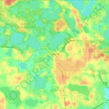
Name: Victoria topographic map, elevation, terrain.

Location: Victoria, Carver County, Minnesota, 55386, United States (44.82533 -93.69297 44.89141 -93.62037)

Average elevation: 978 ft

Minimum elevation: 909 ft

Maximum elevation: 1,060 ft

Carver County trails, hiking, mountain biking, running and outdoor activities

Other topographic maps

Click on a map to view its topography, its elevation and its terrain.

Augusta

United States > Minnesota > Carver County

Average elevation: 965 ft

Assumption

United States > Minnesota > Carver County

Average elevation: 984 ft

Young America

United States > Minnesota > Carver County

Average elevation: 991 ft

Carver Beach

United States > Minnesota > Carver County > Chanhassen

Average elevation: 951 ft

Dahlgren

United States > Minnesota > Carver County

Average elevation: 945 ft

Hollywood

United States > Minnesota > Carver County

Average elevation: 981 ft

Gear up for your next adventure:

🔦Compact Flashlight - Reliable flashlight for emergencies
📱Solar Portable Charger - Solar power bank for charging devices off‑grid
📦Dry Bags Set - Waterproof storage for electronics and clothes
🌲Outdoor Survival Books - Best books on survival skills
GPS Sports Watch - GPS watch for running, hiking and training

As an Amazon Associate, this site earns from qualifying purchases at no extra cost to you.