
Make a donation
Gear up for your next adventure:
As an Amazon Associate, this site earns from qualifying purchases at no extra cost to you.
Maarke topographic map
Click on the map to display elevation.
Make a donation
Gear up for your next adventure:
As an Amazon Associate, this site earns from qualifying purchases at no extra cost to you.
About this map
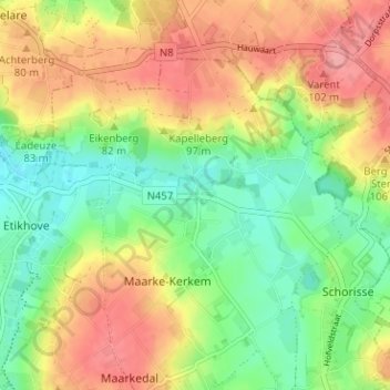
Name: Maarke topographic map, elevation, terrain.
Average elevation: 187 ft
Minimum elevation: 49 ft
Maximum elevation: 341 ft
Make a donation
Gear up for your next adventure:
As an Amazon Associate, this site earns from qualifying purchases at no extra cost to you.
Other topographic maps
Click on a map to view its topography, its elevation and its terrain.
Koppenbergbos-Zuid
België > Oost-Vlaanderen > Oudenaarde > Maarkedal
Het Koppenbergbos is hoofdzakelijk een beukenbos, heraangeplant na WO I als antwoord op de kaalslag tijdens het oorlogsgeweld. Stille getuigen hiervan zijn de loopgraven en vele bomkraters in het noordoostelijk deel van het bos. Verder groeien er ook eik, es, boskers en haagbeuk. In het zuidelijke deel van het…
Average elevation: 167 ft
Etikhove
België > Oost-Vlaanderen > Oudenaarde > Maarkedal
Etikhove ligt in de Vlaamse Ardennen, met een maximale hoogte van 115 meter op de Muziekberg en een minimale hoogte van 20 meter in de vallei van de Maarkebeek. De Bossenareheuvel is ongeveer 100 meter hoog. De Holbeek loopt van noord naar zuid en mondt uit in de Maarkebeek. Het zuiden, bij Louise-Marie, is…
Average elevation: 194 ft
Make a donation
Gear up for your next adventure:
As an Amazon Associate, this site earns from qualifying purchases at no extra cost to you.
Nukerke
België > Oost-Vlaanderen > Oudenaarde > Maarkedal
Nukerke ligt in de Vlaamse Ardennen en de hoogte varieert tussen 30 en 112 meter. Op de Koppenberg vindt men nog het Koppenbergbos, een restant van een veel groter bosgebied. Ook ligt hier nog de Rubberigsbank, wat een uitloper is van het Muziekbos.
Average elevation: 207 ft
Etikhove
België > Oost-Vlaanderen > Oudenaarde > Maarkedal
Etikhove ligt in de Vlaamse Ardennen, met een maximale hoogte van 115 meter op de Muziekberg en een minimale hoogte van 20 meter in de vallei van de Maarkebeek. De Bossenareheuvel is ongeveer 100 meter hoog. De Holbeek loopt van noord naar zuid en mondt uit in de Maarkebeek. Het zuiden, bij Louise-Marie, is…
Average elevation: 194 ft