
Make a donation
Gear up for your next adventure:
As an Amazon Associate, this site earns from qualifying purchases at no extra cost to you.
Schorisse topographic map
Click on the map to display elevation.
Make a donation
Gear up for your next adventure:
As an Amazon Associate, this site earns from qualifying purchases at no extra cost to you.
About this map
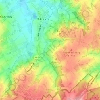
Name: Schorisse topographic map, elevation, terrain.
Average elevation: 253 ft
Minimum elevation: 79 ft
Maximum elevation: 453 ft
Make a donation
Gear up for your next adventure:
As an Amazon Associate, this site earns from qualifying purchases at no extra cost to you.
Other topographic maps
Click on a map to view its topography, its elevation and its terrain.
Make a donation
Gear up for your next adventure:
As an Amazon Associate, this site earns from qualifying purchases at no extra cost to you.
Koppenbergbos-Zuid
België > Oost-Vlaanderen > Oudenaarde > Maarkedal
Het Koppenbergbos is hoofdzakelijk een beukenbos, heraangeplant na WO I als antwoord op de kaalslag tijdens het oorlogsgeweld. Stille getuigen hiervan zijn de loopgraven en vele bomkraters in het noordoostelijk deel van het bos. Verder groeien er ook eik, es, boskers en haagbeuk. In het zuidelijke deel van het…
Average elevation: 167 ft
Make a donation
Gear up for your next adventure:
As an Amazon Associate, this site earns from qualifying purchases at no extra cost to you.