
Make a donation
Gear up for your next adventure:
As an Amazon Associate, this site earns from qualifying purchases at no extra cost to you.
Whiteface Mountain topographic map
Click on the map to display elevation.
Make a donation
Gear up for your next adventure:
As an Amazon Associate, this site earns from qualifying purchases at no extra cost to you.
Whiteface Mountain
Whiteface Mountain is the fifth-highest mountain in the U.S. state of New York, and one of the High Peaks of the Adirondack Mountains. Set apart from most of the other High Peaks, the summit offers a 360-degree view of the Adirondacks and clear-day glimpses of Vermont and even Canada, where the skyscrapers of Montreal, 80 miles (130 km) away, can be seen on a very clear day. Located in the town of Wilmington, about 13 miles (21 km) from Lake Placid, the mountain's east slope is home to a major ski area with the greatest vertical drop east of the Rockies, which hosted the alpine skiing competitions of the 1980 Winter Olympics. Unique among the High Peaks, Whiteface features a developed summit and seasonal accessibility by motor vehicle. Whiteface Memorial Highway reaches a parking area at an elevation of 4,600 feet (1,400 m), with the remaining 267 feet (81 m) being obtained by tunnel and elevator.
Make a donation
Gear up for your next adventure:
As an Amazon Associate, this site earns from qualifying purchases at no extra cost to you.
About this map
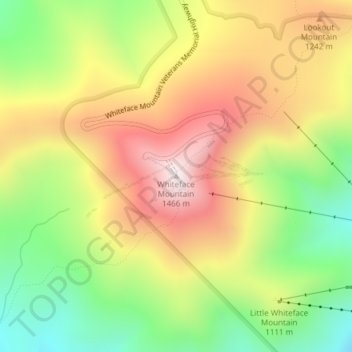
Name: Whiteface Mountain topographic map, elevation, terrain.
Location: Whiteface Mountain, Essex County, New York, United States (44.36573 -73.90303 44.36583 -73.90293)
Average elevation: 3,576 ft
Minimum elevation: 2,395 ft
Maximum elevation: 4,793 ft
Essex County trails, hiking, mountain biking, running and outdoor activities
Make a donation
Gear up for your next adventure:
As an Amazon Associate, this site earns from qualifying purchases at no extra cost to you.
Other topographic maps
Click on a map to view its topography, its elevation and its terrain.
Village of Lake Placid
United States > New York > Essex County
Lake Placid is well known among winter-sports enthusiasts for its skiing, both Alpine and Nordic. Whiteface Mountain (4,867 ft or 1,483 m), in nearby Wilmington about 13 miles (21 km) from Lake Placid, offers skiing, hiking, gondola rides, and mountain biking, and is the only one of the High Peaks that can be…
Average elevation: 1,831 ft
Make a donation
Gear up for your next adventure:
As an Amazon Associate, this site earns from qualifying purchases at no extra cost to you.
Make a donation
Gear up for your next adventure:
As an Amazon Associate, this site earns from qualifying purchases at no extra cost to you.
Fort Ticonderoga
United States > New York > Essex County > Town of Ticonderoga
Average elevation: 141 ft
High Peaks Wilderness
United States > New York > Essex County
The topography ranges from small areas of low-lying swampland (e.g., along the Raquette and Saranac Rivers) to the highest point in New York State at the top of Mount Marcy. Although there is a considerable variety of topography, it is predominantly high mountain country. Like the topography, the forest cover…
Average elevation: 2,070 ft
Make a donation
Gear up for your next adventure:
As an Amazon Associate, this site earns from qualifying purchases at no extra cost to you.
Town of Keene
United States > New York > Essex County
Many of the High Peaks of the Adirondack Park are in or near the town, including Mount Marcy, elevation 5,343 feet (1,629 m), the highest point in New York. The Garden, one of the most popular trailheads in the Adirondacks, is located in the hamlet of Keene Valley and is the eastern end of the Johns Brook…
Average elevation: 2,333 ft
Make a donation
Gear up for your next adventure:
As an Amazon Associate, this site earns from qualifying purchases at no extra cost to you.
Village of Lake Placid
United States > New York > Essex County
Lake Placid is well known among winter-sports enthusiasts for its skiing, both Alpine and Nordic. Whiteface Mountain (4,867 ft or 1,483 m), in nearby Wilmington about 13 miles (21 km) from Lake Placid, offers skiing, hiking, gondola rides, and mountain biking, and is the only one of the High Peaks that can be…
Average elevation: 1,831 ft
Make a donation
Gear up for your next adventure:
As an Amazon Associate, this site earns from qualifying purchases at no extra cost to you.
Village of Lake Placid
United States > New York > Essex County
Lake Placid is well known among winter-sports enthusiasts for its skiing, both Alpine and Nordic. Whiteface Mountain (4,867 ft or 1,483 m), in nearby Wilmington about 13 miles (21 km) from Lake Placid, offers skiing, hiking, gondola rides, and mountain biking, and is the only one of the High Peaks that can be…
Average elevation: 1,831 ft
Essex Chain Lakes Primitive Area
United States > New York > Essex County > Town of Indian Lake
Average elevation: 1,788 ft
Make a donation
Gear up for your next adventure:
As an Amazon Associate, this site earns from qualifying purchases at no extra cost to you.
Fort Ticonderoga
United States > New York > Essex County > Town of Ticonderoga
Average elevation: 141 ft
Make a donation
Gear up for your next adventure:
As an Amazon Associate, this site earns from qualifying purchases at no extra cost to you.
Village of Lake Placid
United States > New York > Essex County
Lake Placid is well known among winter-sports enthusiasts for its skiing, both Alpine and Nordic. Whiteface Mountain (4,867 ft or 1,483 m), in nearby Wilmington about 13 miles (21 km) from Lake Placid, offers skiing, hiking, gondola rides, and mountain biking, and is the only one of the High Peaks that can be…
Average elevation: 1,831 ft
Town of Keene
United States > New York > Essex County
Many of the High Peaks of the Adirondack Park are in or near the town, including Mount Marcy, elevation 5,343 feet (1,629 m), the highest point in New York. The Garden, one of the most popular trailheads in the Adirondacks, is located in the hamlet of Keene Valley and is the eastern end of the Johns Brook…
Average elevation: 2,333 ft
Make a donation
Gear up for your next adventure:
As an Amazon Associate, this site earns from qualifying purchases at no extra cost to you.
Lake Tear of the Clouds
United States > New York > Essex County
Far above the chilly waters of Lake Avalanche at an elevation of 4,293 feet lies summit water, a minute, unpretending, tear of the clouds — as it were — a lovely pool shivering in the breezes of the mountains and sending its limpid surplus through Feldspar Brook to the Opalescent River, the well-spring of…
Average elevation: 4,219 ft
Hoffman Notch Wilderness
United States > New York > Essex County > North Hudson
The forest cover ranges from second growth hardwoods of sapling and pole-size to nearly solid conifer stands of near mature size at the higher elevations. On some of the better soil, exceptionally large diameter hardwoods occur.
Average elevation: 1,690 ft
Make a donation
Gear up for your next adventure:
As an Amazon Associate, this site earns from qualifying purchases at no extra cost to you.