Geolocate

Wittenberg topographic map

Click on the map to display elevation.

About this map

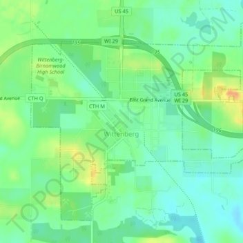
Name: Wittenberg topographic map, elevation, terrain.

Location: Wittenberg, Shawano County, Wisconsin, 54477, United States (44.81235 -89.18388 44.83580 -89.14322)

Average elevation: 1,178 ft

Minimum elevation: 1,132 ft

Maximum elevation: 1,257 ft

Shawano County trails, hiking, mountain biking, running and outdoor activities

Other topographic maps

Click on a map to view its topography, its elevation and its terrain.

Pittsfield

United States > Wisconsin > Shawano County

Average elevation: 804 ft

Pella

United States > Wisconsin > Shawano County

Average elevation: 922 ft

Caroline

United States > Wisconsin > Shawano County

Average elevation: 988 ft

Gear up for your next adventure:

🎒Outdoor Daypacks - Lightweight backpacks designed for carrying maps and essential gear
🦶Carbon Trekking Poles - Reduce knee impact on steep descents with ultra-light poles
🧴Hand Sanitizer - Keep hands clean while hiking
⛑️Personal Locator Beacon - Safety beacon for emergencies
🪓Survival Multi‑Tool - Versatile tool for camp and trail tasks

As an Amazon Associate, this site earns from qualifying purchases at no extra cost to you.