Geolocate

Caroline topographic map

Click on the map to display elevation.

About this map

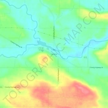
Name: Caroline topographic map, elevation, terrain.

Location: Caroline, Town of Grant, Shawano County, Wisconsin, 54928, United States (44.70081 -88.91149 44.74081 -88.87149)

Average elevation: 988 ft

Minimum elevation: 883 ft

Maximum elevation: 1,155 ft

Shawano County trails, hiking, mountain biking, running and outdoor activities

Other topographic maps

Click on a map to view its topography, its elevation and its terrain.

Town of Wescott

United States > Wisconsin > Shawano County

Average elevation: 837 ft

Wittenberg

United States > Wisconsin > Shawano County

Average elevation: 1,178 ft

Bonduel

United States > Wisconsin > Shawano County

Average elevation: 909 ft

Birnamwood

United States > Wisconsin > Shawano County

Average elevation: 1,302 ft

Aniwa

United States > Wisconsin > Shawano County

Average elevation: 1,407 ft

Bowler

United States > Wisconsin > Shawano County

Average elevation: 1,086 ft

Shawano

United States > Wisconsin > Shawano County > Shawano

Average elevation: 830 ft

Town of Fairbanks

United States > Wisconsin > Shawano County

Average elevation: 1,017 ft

Gear up for your next adventure:

🔥Camping Stove - Portable stove for camping and backcountry cooking
📷Action Camera - Capture your outdoor adventures in HD
📦Dry Bags Set - Waterproof storage for electronics and clothes
📚Navigation Handbooks - Master the art of reading topographic maps and using a compass
🌡️Handheld Weather Meters - Measure wind, temp, and pressure for safe mountain travel

As an Amazon Associate, this site earns from qualifying purchases at no extra cost to you.