
Make a donation
Gear up for your next adventure:
As an Amazon Associate, this site earns from qualifying purchases at no extra cost to you.
Еськино topographic map
Click on the map to display elevation.
Make a donation
Gear up for your next adventure:
As an Amazon Associate, this site earns from qualifying purchases at no extra cost to you.
About this map
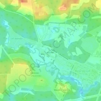
Name: Еськино topographic map, elevation, terrain.
Average elevation: 423 ft
Minimum elevation: 374 ft
Maximum elevation: 502 ft
Make a donation
Gear up for your next adventure:
As an Amazon Associate, this site earns from qualifying purchases at no extra cost to you.
Other topographic maps
Click on a map to view its topography, its elevation and its terrain.
городское поселение Вольгинский
Russia > Vladimir Oblast > Petushinsky District
Average elevation: 407 ft
Make a donation
Gear up for your next adventure:
As an Amazon Associate, this site earns from qualifying purchases at no extra cost to you.
Старое Перепечино
Russia > Vladimir Oblast > Petushinsky District > Старое Перепечино
Average elevation: 377 ft