Geolocate

Meru topographic map

Click on the map to display elevation.

About this map

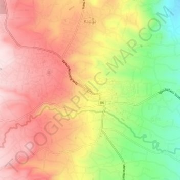
Name: Meru topographic map, elevation, terrain.

Location: Meru, Meru County, East Kenya, 60200, Kenya (0.02899 37.62766 0.06855 37.67444)

Average elevation: 5,259 ft

Minimum elevation: 4,511 ft

Maximum elevation: 5,807 ft

Other topographic maps

Click on a map to view its topography, its elevation and its terrain.

Athi

Kenya > Meru County > Igembe South

Average elevation: 5,220 ft

Kaathene

Kenya > Meru County > Igembe South

Average elevation: 5,896 ft

Gear up for your next adventure:

🖼️Topo Map Wall Art - Decorative topographic prints of famous peaks and regions
🔥Fast-Boil Camping Stoves - Efficient cooking systems for quick trail meals
🦺Reflective Outdoor Gear - Safety gear for low‑light conditions
🌐World Map Poster - Decorative world maps with topographic info
🌄Hiking Binoculars - Compact binoculars for scenic views and trail spotting

As an Amazon Associate, this site earns from qualifying purchases at no extra cost to you.