
Make a donation
Gear up for your next adventure:
As an Amazon Associate, this site earns from qualifying purchases at no extra cost to you.
Alibori Department topographic map
Click on the map to display elevation.
Make a donation
Gear up for your next adventure:
As an Amazon Associate, this site earns from qualifying purchases at no extra cost to you.
Alibori Department
The climate is mostly humid and tropical. The northern regions of Benin, in general, receives one season of rainfall from May to September, compared to the southern regions which receive two spells from March to July and September to November. Harmattan winds blow from the northeast from December through March. The average temperature from April to June is 40 °C (104 °F) in Karimama, while the temperature ranges between 12 and 25 °C (54 and 77 °F) between November and March. The average elevation of the department is 200 m (660 ft) above the mean sea level.
Make a donation
Gear up for your next adventure:
As an Amazon Associate, this site earns from qualifying purchases at no extra cost to you.
About this map
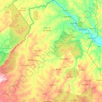
Name: Alibori Department topographic map, elevation, terrain.
Location: Alibori Department, Benin (10.52339 2.02188 12.40920 3.83881)
Average elevation: 863 ft
Minimum elevation: 502 ft
Maximum elevation: 1,660 ft
Make a donation
Gear up for your next adventure:
As an Amazon Associate, this site earns from qualifying purchases at no extra cost to you.
Other topographic maps
Click on a map to view its topography, its elevation and its terrain.
Make a donation
Gear up for your next adventure:
As an Amazon Associate, this site earns from qualifying purchases at no extra cost to you.