
Make a donation
Gear up for your next adventure:
As an Amazon Associate, this site earns from qualifying purchases at no extra cost to you.
Vistale topographic map
Click on the map to display elevation.
Make a donation
Gear up for your next adventure:
As an Amazon Associate, this site earns from qualifying purchases at no extra cost to you.
About this map
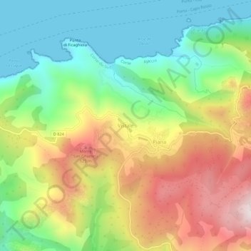
Name: Vistale topographic map, elevation, terrain.
Average elevation: 1,007 ft
Minimum elevation: 0 ft
Maximum elevation: 2,480 ft
Make a donation
Gear up for your next adventure:
As an Amazon Associate, this site earns from qualifying purchases at no extra cost to you.
Other topographic maps
Click on a map to view its topography, its elevation and its terrain.
Make a donation
Gear up for your next adventure:
As an Amazon Associate, this site earns from qualifying purchases at no extra cost to you.
Bocognano
France > Corsica > South Corsica
Bocognano is a mountain village located in the granite part of the island. It occupies an area surrounded by chains of high mountains of the Monte d'Oro massif in the north, and the Monte Renoso massif to the south, through which flows the Gravona river. It is the upper valley of the Gravona, the river taking…
Average elevation: 3,960 ft
Make a donation
Gear up for your next adventure:
As an Amazon Associate, this site earns from qualifying purchases at no extra cost to you.