
Make a donation
Gear up for your next adventure:
As an Amazon Associate, this site earns from qualifying purchases at no extra cost to you.
Orto topographic map
Click on the map to display elevation.
Make a donation
Gear up for your next adventure:
As an Amazon Associate, this site earns from qualifying purchases at no extra cost to you.
About this map
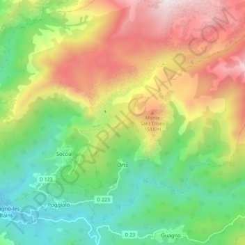
Name: Orto topographic map, elevation, terrain.
Average elevation: 3,465 ft
Minimum elevation: 1,375 ft
Maximum elevation: 6,499 ft
Make a donation
Gear up for your next adventure:
As an Amazon Associate, this site earns from qualifying purchases at no extra cost to you.
Other topographic maps
Click on a map to view its topography, its elevation and its terrain.
Porto-Vecchio
France > Corsica > South Corsica > Porto-Vecchio > Porto-Vecchio
Average elevation: 164 ft
Les Hameaux de Petra Salvini
France > Corsica > South Corsica > Porto-Vecchio > Les Hameaux de Petra Salvini
Average elevation: 423 ft
Make a donation
Gear up for your next adventure:
As an Amazon Associate, this site earns from qualifying purchases at no extra cost to you.
Make a donation
Gear up for your next adventure:
As an Amazon Associate, this site earns from qualifying purchases at no extra cost to you.