
Lake of the Clouds topographic map
Interactive map
Click on the map to display elevation.
About this map
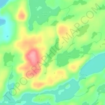
Name: Lake of the Clouds topographic map, elevation, terrain.
Location: Lake of the Clouds, Lake County, Minnesota, United States (48.13859 -91.11538 48.14624 -91.10964)
Average elevation: 1,529 ft
Minimum elevation: 1,381 ft
Maximum elevation: 1,742 ft
Other topographic maps
Click on a map to view its topography, its elevation and its terrain.
Silver Bay
United States > Minnesota > Lake County
Silver Bay, Lake County, Minnesota, 55614, United States
Average elevation: 810 ft
Hum Lake
United States > Minnesota > Lake County
Hum Lake, Lake County, Minnesota, United States
Average elevation: 1,535 ft
Castle Danger
United States > Minnesota > Lake County
Castle Danger, Lake County, Minnesota, United States
Average elevation: 696 ft
Garden Lake
United States > Minnesota > Lake County
Garden Lake, Lake County, Minnesota, United States
Average elevation: 1,398 ft
Griddle Lake
United States > Minnesota > Lake County
Griddle Lake, Lake County, Minnesota, United States
Average elevation: 1,457 ft
Silver Bay
United States > Minnesota > Lake County > Silver Bay > Silver Bay
Silver Bay, Lake County, Minnesota, 55614, United States
Average elevation: 840 ft
Bow Lake
United States > Minnesota > Lake County
Bow Lake, Lake County, Minnesota, United States
Average elevation: 1,565 ft
Beaver Bay
United States > Minnesota > Lake County
Beaver Bay, Lake County, Minnesota, 55601, United States
Average elevation: 696 ft
Two Harbors
United States > Minnesota > Lake County
Two Harbors, Lake County, Minnesota, United States
Average elevation: 725 ft
Gull Lake
United States > Minnesota > Lake County
Gull Lake, Lake County, Minnesota, United States
Average elevation: 1,532 ft