
Make a donation
Gear up for your next adventure:
As an Amazon Associate, this site earns from qualifying purchases at no extra cost to you.
Garden Lake topographic map
Click on the map to display elevation.
Make a donation
Gear up for your next adventure:
As an Amazon Associate, this site earns from qualifying purchases at no extra cost to you.
About this map
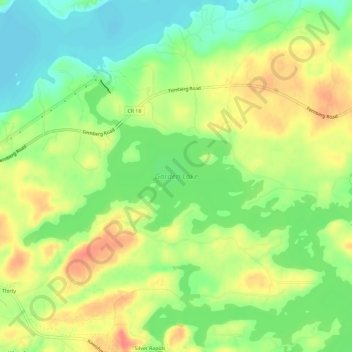
Name: Garden Lake topographic map, elevation, terrain.
Location: Garden Lake, Lake County, Minnesota, United States (47.91222 -91.77648 47.93363 -91.71804)
Average elevation: 1,398 ft
Minimum elevation: 1,299 ft
Maximum elevation: 1,506 ft
Make a donation
Gear up for your next adventure:
As an Amazon Associate, this site earns from qualifying purchases at no extra cost to you.
Other topographic maps
Click on a map to view its topography, its elevation and its terrain.
Silver Bay
United States > Minnesota > Lake County > Silver Bay > Silver Bay
Average elevation: 840 ft
Make a donation
Gear up for your next adventure:
As an Amazon Associate, this site earns from qualifying purchases at no extra cost to you.
Make a donation
Gear up for your next adventure:
As an Amazon Associate, this site earns from qualifying purchases at no extra cost to you.