
Myrtle Beach topographic map
Click on the map to display elevation.
Myrtle Beach
Myrtle Beach features a predominantly flat topography characterized by its coastal plain setting. The area is situated just a few feet above sea level, with an average elevation of approximately 20 feet (6 meters), making it ideal for expansive sandy beaches and shallow tidal estuaries. The region is part of a continuous stretch of shoreline known as the Grand Strand, which spans about 60 miles (97 kilometers). This topography includes barrier islands and wetlands, providing a diverse habitat for various wildlife. The landscape is largely influenced by the Atlantic Ocean, with numerous inlets and swashes, like Wither's Swash, that define the coastal terrain.
About this map
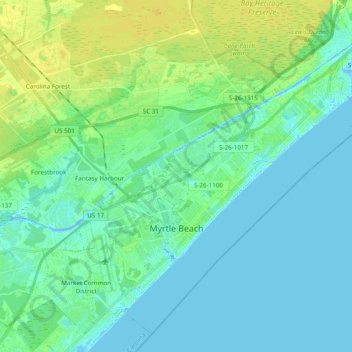
Name: Myrtle Beach topographic map, elevation, terrain.
Location: Myrtle Beach, Horry County, South Carolina, United States (33.64738 -78.97802 33.79126 -78.78547)
Average elevation: 20 ft
Minimum elevation: -16 ft
Maximum elevation: 52 ft
Horry County trails, hiking, mountain biking, running and outdoor activities
Other topographic maps
Click on a map to view its topography, its elevation and its terrain.
Windy Hill Beach
United States > South Carolina > Horry County > North Myrtle Beach
Average elevation: 7 ft
Cherry Grove Beach
United States > South Carolina > Horry County > North Myrtle Beach
Average elevation: 3 ft
Market Common District
United States > South Carolina > Horry County > Myrtle Beach
Average elevation: 16 ft
Ingram Beach
United States > South Carolina > Horry County > North Myrtle Beach > Ocean Drive Beach
Average elevation: 7 ft
Barefoot Resort
United States > South Carolina > Horry County > North Myrtle Beach
Average elevation: 13 ft
Windy Hill Beach
United States > South Carolina > Horry County > North Myrtle Beach
Average elevation: 7 ft
Cherry Grove Beach
United States > South Carolina > Horry County > North Myrtle Beach
Average elevation: 3 ft
Seabrook Plantation
United States > South Carolina > Horry County > North Myrtle Beach
Average elevation: 10 ft
Market Common District
United States > South Carolina > Horry County > Myrtle Beach
Average elevation: 16 ft