
Bellamonte topographic map
Click on the map to display elevation.
About this map
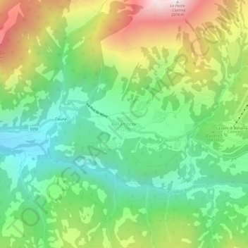
Name: Bellamonte topographic map, elevation, terrain.
Average elevation: 5,075 ft
Minimum elevation: 3,530 ft
Maximum elevation: 7,730 ft
Other topographic maps
Click on a map to view its topography, its elevation and its terrain.
Gruppo del Catinaccio
Italy > Trentino-Alto Adige/Südtirol > Provincia di Trento
Average elevation: 6,112 ft
Fiume Brenta
Italy > Trentino-Alto Adige/Südtirol > Provincia di Trento > Caldonazzo > Brenta
Average elevation: 1,542 ft
Castello San Giovanni
Italy > Trentino-Alto Adige/Südtirol > Provincia di Trento > Baitoni
Average elevation: 1,864 ft
San Giorgio
Italy > Trentino-Alto Adige/Südtirol > Provincia di Trento > Arco > San Giorgio
Average elevation: 305 ft
Pergine Valsugana
Italy > Trentino-Alto Adige/Südtirol > Provincia di Trento
Average elevation: 2,736 ft
Tione di Trento
Italy > Trentino-Alto Adige/Südtirol > Provincia di Trento > Tione di Trento
Average elevation: 4,094 ft
Calliano
Italy > Trentino-Alto Adige/Südtirol > Provincia di Trento > Calliano
Average elevation: 1,998 ft