
Cles topographic map
Click on the map to display elevation.
About this map
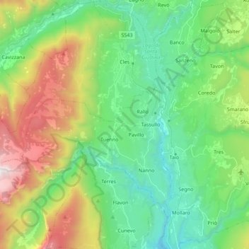
Name: Cles topographic map, elevation, terrain.
Average elevation: 2,946 ft
Minimum elevation: 981 ft
Maximum elevation: 7,343 ft
Other topographic maps
Click on a map to view its topography, its elevation and its terrain.
Gruppo del Catinaccio
Italy > Trentino-Alto Adige/Südtirol > Provincia di Trento
Average elevation: 6,112 ft
Fiume Brenta
Italy > Trentino-Alto Adige/Südtirol > Provincia di Trento > Caldonazzo > Brenta
Average elevation: 1,542 ft
Patascoss
Italy > Trentino-Alto Adige/Südtirol > Provincia di Trento > Madonna di Campiglio
Average elevation: 5,971 ft
Moline
Italy > Trentino-Alto Adige/Südtirol > Provincia di Trento > San Lorenzo in Banale
Average elevation: 3,123 ft
Castello San Giovanni
Italy > Trentino-Alto Adige/Südtirol > Provincia di Trento > Baitoni
Average elevation: 1,864 ft
Ciago
Italy > Trentino-Alto Adige/Südtirol > Provincia di Trento > Vallelaghi > Vezzano
Average elevation: 2,638 ft
Poppekanzel - Pulpito di Cima Pope
Italy > Trentino-Alto Adige/Südtirol > Provincia di Trento
Average elevation: 6,677 ft
Vadaione
Italy > Trentino-Alto Adige/Südtirol > Provincia di Trento > Giustino
Average elevation: 3,537 ft
Alba - Dèlba
Italy > Trentino-Alto Adige/Südtirol > Provincia di Trento > Canazei
Average elevation: 6,043 ft
Soraga
Italy > Trentino-Alto Adige/Südtirol > Provincia di Trento > Soraga di Fassa
Average elevation: 4,948 ft
Malga Grassi
Italy > Trentino-Alto Adige/Südtirol > Provincia di Trento > Riva del Garda
Average elevation: 3,891 ft
Pregasina
Italy > Trentino-Alto Adige/Südtirol > Provincia di Trento > Pregasina
Average elevation: 1,490 ft
Teggiole
Italy > Trentino-Alto Adige/Südtirol > Provincia di Trento > Teggiole
Average elevation: 1,093 ft
Sant'Alessandro
Italy > Trentino-Alto Adige/Südtirol > Provincia di Trento > Riva del Garda
Average elevation: 348 ft