Geolocate

Viola topographic map

Click on the map to display elevation.

About this map

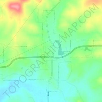
Name: Viola topographic map, elevation, terrain.

Location: Viola, Fulton County, Arkansas, 72583, United States (36.38566 -92.00614 36.41137 -91.96602)

Average elevation: 879 ft

Minimum elevation: 768 ft

Maximum elevation: 1,089 ft

Fulton County trails, hiking, mountain biking, running and outdoor activities

Other topographic maps

Click on a map to view its topography, its elevation and its terrain.

Elizabeth

United States > Arkansas > Fulton County

Average elevation: 764 ft

Gear up for your next adventure:

🔥Plasma Lighters - Windproof lighters that work in any weather condition
🔪Outdoor Multitools - Essential survival tools for gear repair and field use
☀️Outdoor Sunscreen - High protection sunscreen for outdoor activities
🪶LED Camping Lantern - Bright lantern for camp lighting
🧼Biodegradable Camping Soap - Eco‑friendly soap for outdoor hygiene

As an Amazon Associate, this site earns from qualifying purchases at no extra cost to you.