
Schweinhütt topographic map
Interactive map
Click on the map to display elevation.
About this map
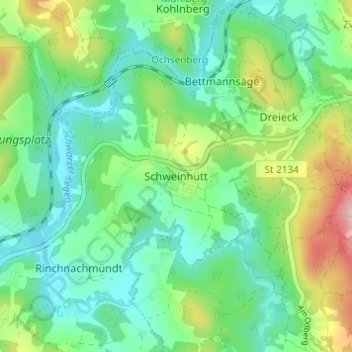
Name: Schweinhütt topographic map, elevation, terrain.
Average elevation: 1,939 ft
Minimum elevation: 1,719 ft
Maximum elevation: 2,464 ft
Other topographic maps
Click on a map to view its topography, its elevation and its terrain.
Reinhartsmais
Deutschland > Bayern > Landkreis Regen > Regen
Reinhartsmais, Regen, Landkreis Regen, Bayern, 94209, Deutschland
Average elevation: 1,982 ft
March
Deutschland > Bayern > Landkreis Regen > Regen
March, Regen, Landkreis Regen, Bayern, Deutschland
Average elevation: 2,057 ft
Edhof
Deutschland > Bayern > Landkreis Regen > Regen > March
Edhof, March, Regen, Landkreis Regen, Bayern, Deutschland
Average elevation: 2,175 ft
Berghäuser
Deutschland > Bayern > Landkreis Regen > Regen > Berghäuser
Berghäuser, Regen, Landkreis Regen, Bayern, Deutschland
Average elevation: 2,083 ft