Geolocate

Van topographic map

Click on the map to display elevation.

About this map

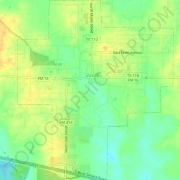
Name: Van topographic map, elevation, terrain.

Location: Van, Van Zandt County, Texas, 75790, United States (32.50500 -95.65415 32.53915 -95.61904)

Average elevation: 499 ft

Minimum elevation: 446 ft

Maximum elevation: 541 ft

Van Zandt County trails, hiking, mountain biking, running and outdoor activities

Other topographic maps

Click on a map to view its topography, its elevation and its terrain.

Colfax

United States > Texas > Van Zandt County

Average elevation: 558 ft

Martins Mill

United States > Texas > Van Zandt County

Average elevation: 515 ft

Gear up for your next adventure:

🎒Trail Energy Bars - High‑calorie bars for hiking energy
🥾Hiking Shoes - Durable and comfortable shoes for trail hiking
🧥Waterproof Jacket for Hiking - Breathable and rugged rain jacket for outdoor excursions
🪶Camping Sleeping Pad - Comfortable sleeping pad for backpacking
🚁Photography Drones - Capture stunning aerial views of landforms and topography

As an Amazon Associate, this site earns from qualifying purchases at no extra cost to you.