
长汀县 topographic map
Interactive map
Click on the map to display elevation.
About this map
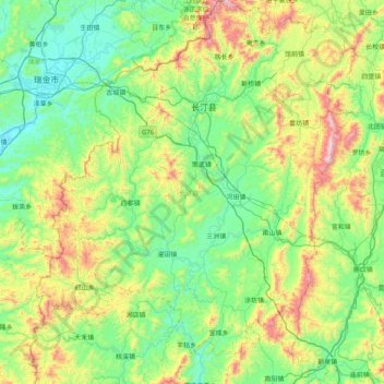
Name: 长汀县 topographic map, elevation, terrain.
Location: 长汀县, 龙岩市, 福建省, 中国 (25.31013 116.00035 26.03626 116.67117)
Average elevation: 1,604 ft
Minimum elevation: 591 ft
Maximum elevation: 4,642 ft
长汀地处福建省西部,东连连城县,南与上杭县、武平县接壤,西邻江西省瑞金市,北接宁化县、清流县及江西省石城县,西南与江西省会昌县毗邻。地形以丘陵为主,汀江纵贯县境。
Other topographic maps
Click on a map to view its topography, its elevation and its terrain.