
Millheim topographic map
Click on the map to display elevation.
About this map
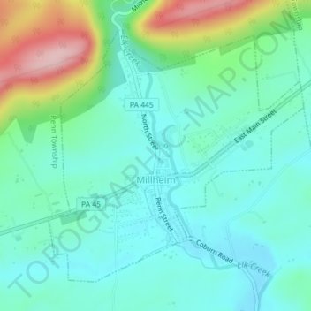
Name: Millheim topographic map, elevation, terrain.
Location: Millheim, Centre County, Pennsylvania, 16854, United States (40.88204 -77.48902 40.90394 -77.45969)
Average elevation: 1,217 ft
Minimum elevation: 1,047 ft
Maximum elevation: 1,729 ft
Centre County trails, hiking, mountain biking, running and outdoor activities
Other topographic maps
Click on a map to view its topography, its elevation and its terrain.
Pleasant View
United States > Pennsylvania > Centre County > Spring Township
Average elevation: 971 ft
Dalevue Park
United States > Pennsylvania > Centre County > State College > Dalevue
Average elevation: 1,086 ft
Loch Lomond Junction
United States > Pennsylvania > Centre County > Rush Township
Average elevation: 1,509 ft