Geolocate

Fate topographic map

Click on the map to display elevation.

About this map

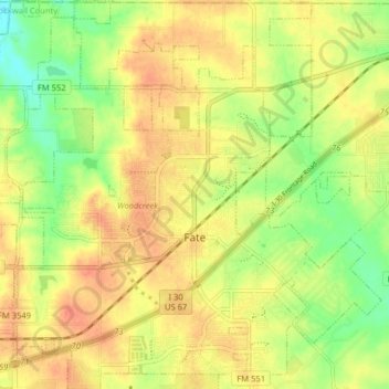
Name: Fate topographic map, elevation, terrain.

Location: Fate, Rockwall County, Texas, 75132, United States (32.91085 -96.42014 32.98219 -96.33975)

Average elevation: 568 ft

Minimum elevation: 479 ft

Maximum elevation: 633 ft

Rockwall County trails, hiking, mountain biking, running and outdoor activities

Other topographic maps

Click on a map to view its topography, its elevation and its terrain.

Heath

United States > Texas > Rockwall County > Heath > Heath

Average elevation: 486 ft

Gear up for your next adventure:

👖Convertible Hiking Pants - Versatile zip-off pants for changing altitudes and temperatures
Backpacking Tent - Lightweight and durable tent for multi‑day hikes
🏥Hiking First Aid Kits - Comprehensive medical kits for remote trail injuries
🔦Powerful Headlamps - Ultra-bright hands-free lighting for night navigation
👟Men's Trail Runners - Lightweight footwear for fast-paced exploration and light hiking

As an Amazon Associate, this site earns from qualifying purchases at no extra cost to you.