
Make a donation
Gear up for your next adventure:
As an Amazon Associate, this site earns from qualifying purchases at no extra cost to you.
Navenby topographic map
Click on the map to display elevation.
Make a donation
Gear up for your next adventure:
As an Amazon Associate, this site earns from qualifying purchases at no extra cost to you.
About this map
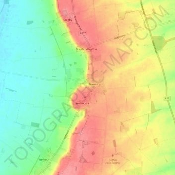
Name: Navenby topographic map, elevation, terrain.
Location: Navenby, North Kesteven, Lincolnshire, England, United Kingdom (53.08856 -0.60483 53.12177 -0.48584)
Average elevation: 154 ft
Minimum elevation: 20 ft
Maximum elevation: 299 ft
Make a donation
Gear up for your next adventure:
As an Amazon Associate, this site earns from qualifying purchases at no extra cost to you.
Other topographic maps
Click on a map to view its topography, its elevation and its terrain.
Make a donation
Gear up for your next adventure:
As an Amazon Associate, this site earns from qualifying purchases at no extra cost to you.
Helpringham
United Kingdom > England > Lincolnshire > North Kesteven > Helpringham
Average elevation: 26 ft
Make a donation
Gear up for your next adventure:
As an Amazon Associate, this site earns from qualifying purchases at no extra cost to you.
Make a donation
Gear up for your next adventure:
As an Amazon Associate, this site earns from qualifying purchases at no extra cost to you.
Make a donation
Gear up for your next adventure:
As an Amazon Associate, this site earns from qualifying purchases at no extra cost to you.
Make a donation
Gear up for your next adventure:
As an Amazon Associate, this site earns from qualifying purchases at no extra cost to you.
Quarrington
United Kingdom > England > Lincolnshire > North Kesteven
According to the Köppen classification, the British Isles experience a maritime climate characterised by relatively cool summers and mild winters. Lincolnshire's position on the east of the Isles allows for a sunnier and warmer climate relative to the national average, and it is one of the driest counties in…
Average elevation: 69 ft
Make a donation
Gear up for your next adventure:
As an Amazon Associate, this site earns from qualifying purchases at no extra cost to you.
Make a donation
Gear up for your next adventure:
As an Amazon Associate, this site earns from qualifying purchases at no extra cost to you.
Make a donation
Gear up for your next adventure:
As an Amazon Associate, this site earns from qualifying purchases at no extra cost to you.
Long Holt Wood
United Kingdom > England > Lincolnshire > North Kesteven > Nocton
Average elevation: 66 ft
Doddington
United Kingdom > England > Lincolnshire > North Kesteven > Doddington
Average elevation: 62 ft
Make a donation
Gear up for your next adventure:
As an Amazon Associate, this site earns from qualifying purchases at no extra cost to you.
Threekingham
United Kingdom > England > Lincolnshire > North Kesteven > Threekingham
Average elevation: 98 ft
Make a donation
Gear up for your next adventure:
As an Amazon Associate, this site earns from qualifying purchases at no extra cost to you.
Make a donation
Gear up for your next adventure:
As an Amazon Associate, this site earns from qualifying purchases at no extra cost to you.
Three Kings Deer
United Kingdom > England > Lincolnshire > North Kesteven > Threekingham
Average elevation: 79 ft