Geolocate

Hvar topographic map

Click on the map to display elevation.

Hvar

The island has a typical Mediterranean vegetation, mostly bare with woody scrub at higher, steeper elevations, turning to pine forests on the lower slopes with Holm oak (Orno-Quercetum ilicis), Aleppo pines (Pinus halapensis Mill) and Black pines (Pinus nigra dalmatica). The islet of Šćedro is especially rich in various Mediterranean trees and plants.

Wikipedia (CC-BY-SA 3.0)

About this map

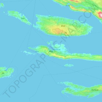
Name: Hvar topographic map, elevation, terrain.

Location: Hvar, Split-Dalmatia County, Croatia (43.11218 16.36633 43.23570 17.19672)

Average elevation: 190 ft

Minimum elevation: -7 ft

Maximum elevation: 5,164 ft

Other topographic maps

Click on a map to view its topography, its elevation and its terrain.

Baška Voda

Croatia > Split-Dalmatia County > Baška Voda

Average elevation: 709 ft

Paklina

Croatia > Split-Dalmatia County > Tučepi > Paklina

Average elevation: 712 ft

Jelsa

Croatia > Split-Dalmatia County > Jelsa

Average elevation: 285 ft

Umčani

Croatia > Split-Dalmatia County

Average elevation: 728 ft

Gear up for your next adventure:

🌡️Portable Weather Meter - Track weather conditions on the trail
🏕️Tent Footprint - Protect your tent base from wear
🚪Portable Camp Chair - Foldable chair for comfort at camp
🧼Biodegradable Camping Soap - Eco‑friendly soap for outdoor hygiene
🔋Rechargeable Batteries - Power up your outdoor devices

As an Amazon Associate, this site earns from qualifying purchases at no extra cost to you.