
Granby topographic map
Interactive map
Click on the map to display elevation.
About this map
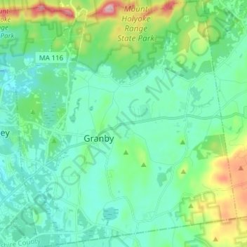
Name: Granby topographic map, elevation, terrain.
Average elevation: 358 ft
Minimum elevation: 164 ft
Maximum elevation: 1,050 ft
Hampshire County trails, hiking, mountain biking, running and outdoor activities
Other topographic maps
Click on a map to view its topography, its elevation and its terrain.
Mill River Recreation Area
United States > Massachusetts > Hampshire County > Amherst > North Amherst
Average elevation: 217 ft
Wildwood Conservation Area
United States > Massachusetts > Hampshire County > Amherst
Average elevation: 292 ft
Worthington Corners
United States > Massachusetts > Hampshire County > Worthington
Average elevation: 1,476 ft
Cushman
United States > Massachusetts > Hampshire County > Amherst > Cushman
Average elevation: 338 ft