
Make a donation
Gear up for your next adventure:
As an Amazon Associate, this site earns from qualifying purchases at no extra cost to you.
Evansville topographic map
Click on the map to display elevation.
Make a donation
Gear up for your next adventure:
As an Amazon Associate, this site earns from qualifying purchases at no extra cost to you.
About this map
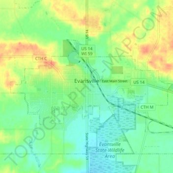
Name: Evansville topographic map, elevation, terrain.
Location: Evansville, Rock County, Wisconsin, 53536, United States (42.76444 -89.33051 42.79285 -89.25959)
Average elevation: 922 ft
Minimum elevation: 869 ft
Maximum elevation: 1,001 ft
Rock County trails, hiking, mountain biking, running and outdoor activities
Make a donation
Gear up for your next adventure:
As an Amazon Associate, this site earns from qualifying purchases at no extra cost to you.
Other topographic maps
Click on a map to view its topography, its elevation and its terrain.
Johnstown Center
United States > Wisconsin > Rock County > Town of Johnstown
Average elevation: 951 ft
Make a donation
Gear up for your next adventure:
As an Amazon Associate, this site earns from qualifying purchases at no extra cost to you.