
Make a donation
Gear up for your next adventure:
As an Amazon Associate, this site earns from qualifying purchases at no extra cost to you.
Hammelbach topographic map
Click on the map to display elevation.
Make a donation
Gear up for your next adventure:
As an Amazon Associate, this site earns from qualifying purchases at no extra cost to you.
Hammelbach
Hammelbach liegt auf 438 m ü. NHN im Odenwald auf der Passhöhe zwischen dem Weschnitztal im Norden und dem Ulfenbachtal im Süden und ist somit eines der nördlichen Tore zu der Region Überwald. Die Quellen der beiden Flussläufe liegen in unmittelbarer Nähe der Ortslage. Der Oberlauf des Ulfenbachs von Hammelbach bis Wahlen ist auch unter dem Namen Hammelbach bekannt. Die Gemarkung erstreckt sich vom 536 Meter hohen Wagenberg im Westen nach Osten über den 507 Meter hohen Weihwesel, die Gaßbach und die Krumme Tanne bis zum Hirschbrunnen und zum Jagdhaus Hirschwiese nördlich von Gras-Ellenbach.
Make a donation
Gear up for your next adventure:
As an Amazon Associate, this site earns from qualifying purchases at no extra cost to you.
About this map
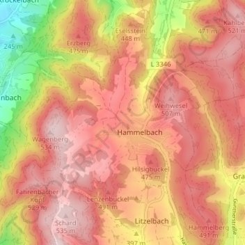
Name: Hammelbach topographic map, elevation, terrain.
Average elevation: 1,430 ft
Minimum elevation: 728 ft
Maximum elevation: 1,781 ft
Make a donation
Gear up for your next adventure:
As an Amazon Associate, this site earns from qualifying purchases at no extra cost to you.
Other topographic maps
Click on a map to view its topography, its elevation and its terrain.
Lindenfels
Deutschland > Hessen > Kreis Bergstraße > Lindenfels > Lindenfels
Der heilklimatische Kurort Lindenfels ist im Süden Hessens unter vielen Dörfern das einzige Städtchen im Vorderen Odenwald. Die Altstadt liegt in 350 Metern Höhe auf der Sattelfläche zwischen dem bewaldeten Schenkenberg (479,6 m ü. NN) im Nordosten und einem Bergsporn mit der Burg Lindenfels (410,4 m ü.…
Average elevation: 1,053 ft
Make a donation
Gear up for your next adventure:
As an Amazon Associate, this site earns from qualifying purchases at no extra cost to you.
Fahrenbacher Str. 108, 64658 Fürth, Deutschland
Deutschland > Hessen > Kreis Bergstraße > Fürth > Fahrenbach
Average elevation: 676 ft
Im großen Stück
Deutschland > Hessen > Kreis Bergstraße > Lampertheim > Hüttenfeld
Average elevation: 322 ft
Make a donation
Gear up for your next adventure:
As an Amazon Associate, this site earns from qualifying purchases at no extra cost to you.
Zotzenbach
Deutschland > Hessen > Kreis Bergstraße
Zotzenbach liegt beiderseits des gleichnamigen Bachs im Weschnitztal im Vorderen Odenwald ca. 30 km nördlich von Heidelberg. Es ist außer dem nahen Weiler Münschbach der einzige Ortsteil, der südlich von Rimbach-Mitte und östlich der Weschnitz liegt. Die ausgedehnte Gemarkung von Zotzenbach erstreckt sich…
Average elevation: 755 ft
Make a donation
Gear up for your next adventure:
As an Amazon Associate, this site earns from qualifying purchases at no extra cost to you.
Tromm
Deutschland > Hessen > Kreis Bergstraße > Zotzenbach
Die Tromm ist ein markanter Bergrücken im Odenwald im Südosten des Kreises Bergstraße in Südhessen, der sich östlich des Weschnitztales (mit den Dörfern Mörlenbach und Rimbach) rund 400 m über das Tal erhebt und an seinem höchsten Punkt eine Höhe von 576,8 m ü. NHN erreicht.
Average elevation: 1,391 ft
Reichenbach
Deutschland > Hessen > Kreis Bergstraße > Lautertal
Die erste urkundliche Erwähnung des Orts erfolgte 1012 unter dem Namen Richinbach, als König Heinrich II. auf Bitten von Abt Bodo des Klosters Lorsch diesem den Forst- und Wildbann innerhalb der Mark Michelstadt und der „Mark Heppenheim“ auf ewig verlieh. Der Name Reonga, der in den Grenzbeschreibungen…
Average elevation: 1,030 ft
Schannenbach
Deutschland > Hessen > Kreis Bergstraße > Lautertal > Schannenbach
Die Statistisch-topographisch-historische Beschreibung des Großherzogthums Hessen berichtet 1829 über Schannenbach.
Average elevation: 1,522 ft
Make a donation
Gear up for your next adventure:
As an Amazon Associate, this site earns from qualifying purchases at no extra cost to you.
Make a donation
Gear up for your next adventure:
As an Amazon Associate, this site earns from qualifying purchases at no extra cost to you.
Gadernheim
Deutschland > Hessen > Kreis Bergstraße > Lautertal
Gadernheim liegt im Vorderen Odenwald an der oberen Lauter und östlich der Kerngemeinde Reichenbach. Zur Gemarkung gehört im Nordosten das Quelltal der Lauter und die höchste Erhebung im hessischen Odenwald, die 605 Meter hohe bewaldete Neunkircher Höhe mit dem Kaiserturm.
Average elevation: 1,352 ft
Erlenbach
Deutschland > Hessen > Kreis Bergstraße > Fürth > Erlenbach
Die Statistisch-topographisch-historische Beschreibung des Großherzogthums Hessen berichtet 1829 über Erlenbach.
Average elevation: 1,010 ft
Zum Gänsberg 1, 64658 Fürth, Deutschland
Deutschland > Hessen > Kreis Bergstraße > Fürth > Steinbach
Average elevation: 725 ft
Make a donation
Gear up for your next adventure:
As an Amazon Associate, this site earns from qualifying purchases at no extra cost to you.