Geolocate

Lawrence topographic map

Click on the map to display elevation.

About this map

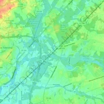
Name: Lawrence topographic map, elevation, terrain.

Location: Lawrence, Lawrence Township, Mercer County, New Jersey, 08619, United States (40.23400 -74.71960 40.31400 -74.63960)

Average elevation: 85 ft

Minimum elevation: 39 ft

Maximum elevation: 197 ft

Mercer County trails, hiking, mountain biking, running and outdoor activities

Other topographic maps

Click on a map to view its topography, its elevation and its terrain.

Hopewell

United States > New Jersey > Mercer County

Average elevation: 240 ft

Hightstown

United States > New Jersey > Mercer County

Average elevation: 112 ft

Gear up for your next adventure:

🩹Survival Bandages - High‑quality bandages for emergencies
🧴Hand Sanitizer - Keep hands clean while hiking
🛰️Satellite Messengers - Emergency SOS and two-way messaging for off-grid adventures
🚁Photography Drones - Capture stunning aerial views of landforms and topography
👓Polarized Sunglasses - Outdoor sunglasses for glare reduction

As an Amazon Associate, this site earns from qualifying purchases at no extra cost to you.