
Hightstown topographic map
Click on the map to display elevation.
About this map
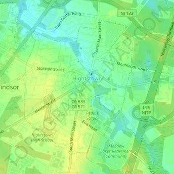
Name: Hightstown topographic map, elevation, terrain.
Location: Hightstown, Mercer County, New Jersey, United States (40.25775 -74.53760 40.27863 -74.51386)
Average elevation: 112 ft
Minimum elevation: 75 ft
Maximum elevation: 138 ft
Mercer County trails, hiking, mountain biking, running and outdoor activities
Other topographic maps
Click on a map to view its topography, its elevation and its terrain.
Rosedale Park
United States > New Jersey > Mercer County > Hopewell Township
Average elevation: 184 ft
Twin Rivers
United States > New Jersey > Mercer County > East Windsor Township
Average elevation: 115 ft
Braeburn Heights
United States > New Jersey > Mercer County > Ewing Township
Average elevation: 112 ft
Princeton Colonial Park
United States > New Jersey > Mercer County > Princeton Colonial Park
Average elevation: 95 ft
Hamilton Square
United States > New Jersey > Mercer County > Hamilton Township > Hamilton Square
Average elevation: 95 ft
Harneys Corner
United States > New Jersey > Mercer County > Lawrence Township
Average elevation: 85 ft
Chewalla Park
United States > New Jersey > Mercer County > Hamilton Township > Chewalla Park
Average elevation: 69 ft
Van Nest Park
United States > New Jersey > Mercer County > West Windsor > Old Mill Farms
Average elevation: 89 ft