
Pai topographic map
Interactive map
Click on the map to display elevation.
About this map
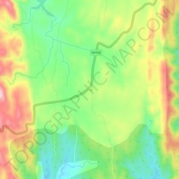
Name: Pai topographic map, elevation, terrain.
Location: Pai, Girwa Tehsil, Udaipur District, Rajasthan, 313031, India (24.41658 73.55593 24.45658 73.59593)
Average elevation: 2,641 ft
Minimum elevation: 2,310 ft
Maximum elevation: 3,071 ft
Other topographic maps
Click on a map to view its topography, its elevation and its terrain.
Udaipur
India > Rajasthan > Girwa Tehsil
Udaipur, Girwa Tehsil, Udaipur District, Rajasthan, 313001, India
Average elevation: 2,152 ft
Bichhri
India > Rajasthan > Girwa Tehsil
Bichhri, Girwa Tehsil, Udaipur District, Rajasthan, India
Average elevation: 1,791 ft
Panchwati Circle
India > Rajasthan > Girwa Tehsil > Udaipur
Panchwati Circle, Udaipur, Girwa Tehsil, Udaipur District, Rajasthan, 313001, India
Average elevation: 1,923 ft
Bargaon
India > Rajasthan > Girwa Tehsil
Bargaon, Girwa Tehsil, Udaipur District, Rajasthan, 313004, India
Average elevation: 1,985 ft
Debari
India > Rajasthan > Girwa Tehsil
Debari, Girwa Tehsil, Udaipur District, Rajasthan, 313003, India
Average elevation: 1,982 ft