Geolocate

Windsor topographic map

Click on the map to display elevation.

About this map

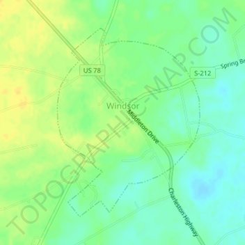
Name: Windsor topographic map, elevation, terrain.

Location: Windsor, Aiken County, South Carolina, 29856, United States (33.46958 -81.52241 33.49033 -81.50358)

Average elevation: 384 ft

Minimum elevation: 344 ft

Maximum elevation: 420 ft

Aiken County trails, hiking, mountain biking, running and outdoor activities

Other topographic maps

Click on a map to view its topography, its elevation and its terrain.

Langley

United States > South Carolina > Aiken County > Burnettown

Average elevation: 269 ft

Couchton

United States > South Carolina > Aiken County

Average elevation: 413 ft

Aiken

United States > South Carolina > Aiken County > Aiken > Aiken

Average elevation: 469 ft

Hunters Glen

United States > South Carolina > Aiken County > Aiken

Average elevation: 446 ft

Gear up for your next adventure:

🔪Outdoor Multitools - Essential survival tools for gear repair and field use
🛰️Satellite Messengers - Emergency SOS and two-way messaging for off-grid adventures
📶Vehicle Signal Boosters - Improve reception in rural areas while driving to trailheads
🥄Camping Utensil Set - Lightweight utensils for outdoor meals
🧭Orienteering Set - Complete compass and map reading kit

As an Amazon Associate, this site earns from qualifying purchases at no extra cost to you.