Geolocate

Kyoto topographic map

Click on the map to display elevation.

👉 Easily get elevation data in JSON, GeoTIFF and KML formats using Elevation API
Thank you for supporting this site ❤️
Make a donation

About this map

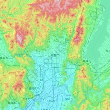
Name: Kyoto topographic map, elevation, terrain.

Location: Kyoto, Kyoto Prefecture, 602-8570, Japan (34.86104 135.59561 35.18104 135.91561)

Average elevation: 794 ft

Minimum elevation: 10 ft

Maximum elevation: 3,035 ft

Other topographic maps

Click on a map to view its topography, its elevation and its terrain.

Higashiyama Ward

Japan > Kyoto

Average elevation: 246 ft

Arisugawa River

Japan > Kyoto

Average elevation: 325 ft

Saihō Temple

Japan > Kyoto

Average elevation: 318 ft

Fushimi Ward

Japan > Kyoto

Average elevation: 259 ft

Gear up for your next adventure:

🧭Hiking Compass - Precision compass for reliable navigation in the wilderness
🪶Paracord Bracelet - Survival bracelet with built‑in tools
🛡️Insect Repellent - Protection against bugs during outdoor activities
🕶️Glacier Sunglasses - Side shields to protect eyes from high-altitude snow glare
🧥Waterproof Jacket for Hiking - Breathable and rugged rain jacket for outdoor excursions

As an Amazon Associate, this site earns from qualifying purchases at no extra cost to you.