Geolocate

Fushimi Ward topographic map

Click on the map to display elevation.

About this map

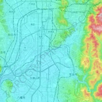
Name: Fushimi Ward topographic map, elevation, terrain.

Location: Fushimi Ward, Kyoto, Kyoto Prefecture, Japan (34.87492 135.70317 34.97718 135.87844)

Average elevation: 259 ft

Minimum elevation: 0 ft

Maximum elevation: 1,877 ft

Other topographic maps

Click on a map to view its topography, its elevation and its terrain.

Kyoto

Japan > Kyoto

Average elevation: 794 ft

Saihō Temple

Japan > Kyoto

Average elevation: 318 ft

Arisugawa River

Japan > Kyoto

Average elevation: 325 ft

Gear up for your next adventure:

🔌Solar Panel Charger - Charge gear sustainably outdoors
🧼Biodegradable Camping Soap - Eco‑friendly soap for outdoor hygiene
🎒Trail Energy Bars - High‑calorie bars for hiking energy
👟Men's Trail Runners - Lightweight footwear for fast-paced exploration and light hiking
🕶️Glacier Sunglasses - Side shields to protect eyes from high-altitude snow glare

As an Amazon Associate, this site earns from qualifying purchases at no extra cost to you.