Geolocate

Morecambe topographic map

Click on the map to display elevation.

About this map

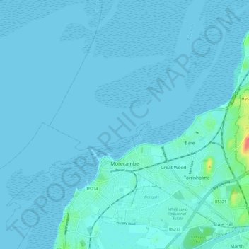
Name: Morecambe topographic map, elevation, terrain.

Location: Morecambe, Lancaster, Lancashire, England, United Kingdom (54.04973 -2.91764 54.11485 -2.82105)

Average elevation: 10 ft

Minimum elevation: 0 ft

Maximum elevation: 190 ft

Other topographic maps

Click on a map to view its topography, its elevation and its terrain.

Hest Bank

United Kingdom > England > Lancashire > Lancaster

Average elevation: 82 ft

Notts Pot

United Kingdom > England > Lancashire > Lancaster > Leck

Average elevation: 1,171 ft

Bailrigg

United Kingdom > England > Lancashire > Lancaster

Average elevation: 190 ft

Hornby

United Kingdom > England > Lancashire > Lancaster

Average elevation: 184 ft

Galgate

United Kingdom > England > Lancashire > Lancaster

Average elevation: 141 ft

Glasson Dock

United Kingdom > England > Lancashire > Lancaster

Average elevation: 23 ft

Dolphinholme

United Kingdom > England > Lancashire > Lancaster

Average elevation: 328 ft

Melling

United Kingdom > England > Lancashire > Lancaster

Average elevation: 167 ft

Littledale

United Kingdom > England > Lancashire > Lancaster

Average elevation: 837 ft

White Hill

United Kingdom > England > Lancashire > Lancaster

Average elevation: 1,493 ft

Arkholme

United Kingdom > England > Lancashire > Lancaster

Average elevation: 187 ft

Lowgill

United Kingdom > England > Lancashire > Lancaster

Average elevation: 676 ft

Aldcliffe

United Kingdom > England > Lancashire > Lancaster

Average elevation: 75 ft

Warton Crag

United Kingdom > England > Lancashire > Lancaster > Warton

Average elevation: 148 ft

Stodday

United Kingdom > England > Lancashire > Lancaster

Average elevation: 85 ft

Lower Burrow

United Kingdom > England > Lancashire > Lancaster > Bailrigg

Average elevation: 118 ft

Capernwray

United Kingdom > England > Lancashire > Lancaster

Average elevation: 197 ft

Brookhouse

United Kingdom > England > Lancashire > Lancaster

Average elevation: 269 ft

Hayshaw Fell

United Kingdom > England > Lancashire > Lancaster

Average elevation: 741 ft

Hazelrigg Wood

United Kingdom > England > Lancashire > Lancaster > Bailrigg

Average elevation: 249 ft

Aldcliffe

United Kingdom > England > Lancashire > Lancaster

Average elevation: 75 ft

Gear up for your next adventure:

🥄Camping Utensil Set - Lightweight utensils for outdoor meals
🥇GPS Hiking Watch - Multi‑sport GPS watch with navigation and trail tracking
👓Polarized Sunglasses - Outdoor sunglasses for glare reduction
🪵Folding Camp Saw - Compact saw for wood and campsite work
🧴Hand Sanitizer - Keep hands clean while hiking

As an Amazon Associate, this site earns from qualifying purchases at no extra cost to you.