Make a donation
Gear up for your next adventure:
As an Amazon Associate, this site earns from qualifying purchases at no extra cost to you.
Aldcliffe topographic map
Click on the map to display elevation.
Make a donation
Gear up for your next adventure:
As an Amazon Associate, this site earns from qualifying purchases at no extra cost to you.
About this map
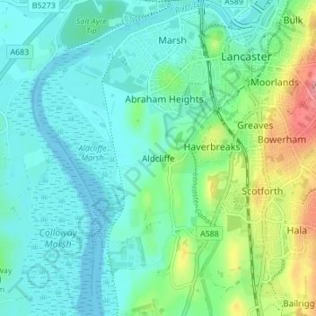
Name: Aldcliffe topographic map, elevation, terrain.
Average elevation: 75 ft
Minimum elevation: -3 ft
Maximum elevation: 308 ft
Make a donation
Gear up for your next adventure:
As an Amazon Associate, this site earns from qualifying purchases at no extra cost to you.
Other topographic maps
Click on a map to view its topography, its elevation and its terrain.
Nether Kellet
United Kingdom > England > Lancashire > Lancaster > Nether Kellet
Average elevation: 256 ft
Arnside & Silverdale National Landscape
United Kingdom > England > Lancashire > Lancaster
Average elevation: 72 ft
Make a donation
Gear up for your next adventure:
As an Amazon Associate, this site earns from qualifying purchases at no extra cost to you.
Melling-with-Wrayton
United Kingdom > England > Lancashire > Lancaster > Melling
Average elevation: 184 ft
Make a donation
Gear up for your next adventure:
As an Amazon Associate, this site earns from qualifying purchases at no extra cost to you.
Make a donation
Gear up for your next adventure:
As an Amazon Associate, this site earns from qualifying purchases at no extra cost to you.
Bolton-le-Sands
United Kingdom > England > Lancashire > Lancaster > Bolton le Sands
Average elevation: 75 ft
Make a donation
Gear up for your next adventure:
As an Amazon Associate, this site earns from qualifying purchases at no extra cost to you.
