
Grabouw topographic map
Click on the map to display elevation.
Grabouw
The Elgin valley is South Africa's coolest climate wine-growing region and a range of other geographic factors (for example, its proximity to the Atlantic Ocean, cool temperatures, plentiful winter rainfall, prevailing wind directions, and altitude) have created a set of conditions for wine growing which are markedly different to those in surrounding areas. Of the many varietals grown in the region, special attention has been paid to Sauvignon Blanc and Pinot Noir.
About this map
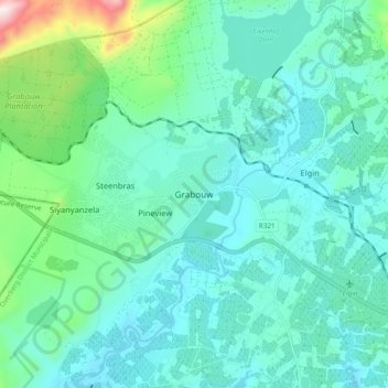
Name: Grabouw topographic map, elevation, terrain.
Average elevation: 1,175 ft
Minimum elevation: 810 ft
Maximum elevation: 2,881 ft
Other topographic maps
Click on a map to view its topography, its elevation and its terrain.
Bot River
South Africa > Western Cape > Overberg District Municipality > Theewaterskloof Local Municipality
Average elevation: 1,004 ft
Salt River
South Africa > Western Cape > Overberg District Municipality > Theewaterskloof Local Municipality
Average elevation: 787 ft