
Bot River topographic map
Click on the map to display elevation.
About this map
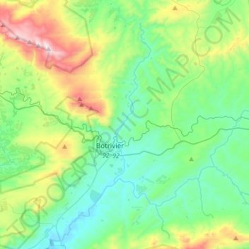
Name: Bot River topographic map, elevation, terrain.
Average elevation: 1,004 ft
Minimum elevation: 0 ft
Maximum elevation: 3,898 ft
Other topographic maps
Click on a map to view its topography, its elevation and its terrain.
Villiersdorp
South Africa > Western Cape > Overberg District Municipality > Theewaterskloof Local Municipality
Average elevation: 1,870 ft
Riviersonderend
South Africa > Western Cape > Overberg District Municipality > Theewaterskloof Local Municipality
Average elevation: 696 ft
Grabouw
South Africa > Western Cape > Overberg District Municipality > Theewaterskloof Local Municipality
The Elgin valley is South Africa's coolest climate wine-growing region and a range of other geographic factors (for example, its proximity to the Atlantic Ocean, cool temperatures, plentiful winter rainfall, prevailing wind directions, and altitude) have created a set of conditions for wine growing which are…
Average elevation: 1,175 ft
Caledon
South Africa > Western Cape > Overberg District Municipality > Theewaterskloof Local Municipality
Average elevation: 1,020 ft
Salt River
South Africa > Western Cape > Overberg District Municipality > Theewaterskloof Local Municipality
Average elevation: 787 ft