
Mount Stuart topographic map
Click on the map to display elevation.
Mount Stuart
Mount Stuart is more notable for its local relief than for its absolute elevation. For example, the south face rises 5,000 feet (1,500 m) in just 2 horizontal miles (3.2 km). The northeast and northwest sides of the mountain exhibit similar steep relief. Due to its location away from higher peaks, Mount Stuart has a topographic prominence of 5,354 feet (1,632 m), making it the sixth most prominent in the state. The rock of Mount Stuart is rugged due to the extensive jointing of the granite. The north slopes of the mountain shelter three glaciers - Stuart, Ice Cliff and Sherpa Glaciers from west to east.
About this map
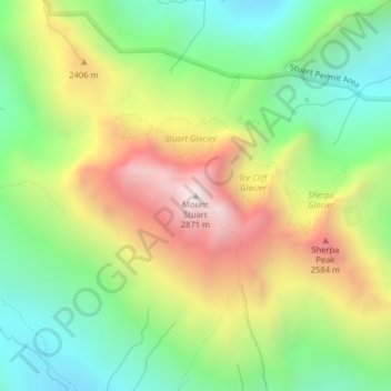
Name: Mount Stuart topographic map, elevation, terrain.
Location: Mount Stuart, Chelan County, Washington, United States (47.47510 -120.90204 47.47520 -120.90194)
Average elevation: 6,919 ft
Minimum elevation: 5,217 ft
Maximum elevation: 9,331 ft
Other topographic maps
Click on a map to view its topography, its elevation and its terrain.
Wenatchee
United States > Washington > Chelan County
Wenatchee is characterized by its diverse topography, nestled at an average elevation of approximately 800 feet. The city is situated in a valley surrounded by significant geographical features, including the rugged foothills of the Cascade Mountains, which rise sharply to elevations of over 4,500 feet just to…
Average elevation: 991 ft
Leavenworth
United States > Washington > Chelan County
Leavenworth, Washington, is nestled at approximately 1,171 feet (357 meters) above sea level in the eastern foothills of the Cascade Mountains. The town is surrounded by rugged terrain, with steep slopes that rise sharply to elevations exceeding 5,000 feet (1,524 meters), and prominent peaks such as Icicle…
Average elevation: 1,371 ft
Saddle Rock Natural Area
United States > Washington > Chelan County > Wenatchee
Average elevation: 1,470 ft
Leavenworth
United States > Washington > Chelan County
Leavenworth is situated in the Cascade Mountains at an elevation of 1,168 feet (356 m) above sea level and is surrounded by mountains that range from 5,000 to 8,000 feet (1,500 to 2,400 m) in height. The city lies along the Wenatchee River near its confluence with Icicle Creek. According to the United States…
Average elevation: 1,371 ft
Entiat Slopes Natural Area Preserve
United States > Washington > Chelan County
Average elevation: 2,136 ft
Entiat Slopes Natural Area Preserve
United States > Washington > Chelan County
Average elevation: 2,136 ft