
Thank you for supporting this site ❤️
Make a donation
Make a donation
Gear up for your next adventure:
As an Amazon Associate, this site earns from qualifying purchases at no extra cost to you.
Preston Hollow topographic map
Click on the map to display elevation.
Thank you for supporting this site ❤️
Make a donation
Make a donation
Gear up for your next adventure:
As an Amazon Associate, this site earns from qualifying purchases at no extra cost to you.
About this map
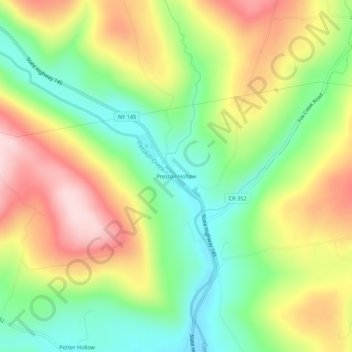
Name: Preston Hollow topographic map, elevation, terrain.
Average elevation: 1,220 ft
Minimum elevation: 787 ft
Maximum elevation: 1,759 ft
Albany County trails, hiking, mountain biking, running and outdoor activities
Thank you for supporting this site ❤️
Make a donation
Make a donation
Gear up for your next adventure:
As an Amazon Associate, this site earns from qualifying purchases at no extra cost to you.
Other topographic maps
Click on a map to view its topography, its elevation and its terrain.
Preston-Potter Hollow
United States > New York > Albany County > Town of Rensselaerville
It is also the topographical location of Potter Hollow.
Average elevation: 1,217 ft