
Westminster topographic map
Click on the map to display elevation.
About this map
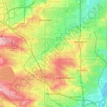
Name: Westminster topographic map, elevation, terrain.
Location: Westminster, Adams County, Colorado, United States (39.81807 -105.16554 39.96854 -104.98768)
Average elevation: 5,348 ft
Minimum elevation: 5,079 ft
Maximum elevation: 5,699 ft
Adams County trails, hiking, mountain biking, running and outdoor activities
Other topographic maps
Click on a map to view its topography, its elevation and its terrain.
Bennett
United States > Colorado > Adams County
Bennett is located at coordinates 39°45′32″N 104°25′39″W / 39.7589°N 104.4275°W / 39.7589; -104.4275 at an elevation of 5486 at the intersection of State Highways 36 and 79, just north of Interstate 70.
Average elevation: 5,551 ft
Westminster
United States > Colorado > Adams County > Westminster > Westminster
Average elevation: 5,446 ft
Bennett
United States > Colorado > Adams County
Bennett is located at coordinates 39°45′32″N 104°25′39″W / 39.7589°N 104.4275°W / 39.7589; -104.4275 at an elevation of 5486 at the intersection of State Highways 36 and 79, just north of Interstate 70.
Average elevation: 5,551 ft
Broomfield McKay Bike Park
United States > Colorado > Adams County > Broomfield
Average elevation: 5,253 ft