
Watkins topographic map
Click on the map to display elevation.
About this map
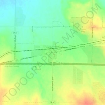
Name: Watkins topographic map, elevation, terrain.
Location: Watkins, Adams County, Colorado, 80137, United States (39.72434 -104.62320 39.76434 -104.58320)
Average elevation: 5,538 ft
Minimum elevation: 5,466 ft
Maximum elevation: 5,623 ft
Adams County trails, hiking, mountain biking, running and outdoor activities
Other topographic maps
Click on a map to view its topography, its elevation and its terrain.
Aurora
United States > Colorado > Adams County
Aurora's official elevation, posted on signs at the city limits, is 5,471 feet (1,668 m). However, the city spans a difference in elevation of nearly 1,000 feet (300 m). The lowest elevation of 5,285 feet (1,611 m) is found at the point where Sand Creek crosses the city limit in the northwest corner of the…
Average elevation: 5,548 ft
Bennett
United States > Colorado > Adams County
Bennett is located at coordinates 39°45′32″N 104°25′39″W / 39.7589°N 104.4275°W / 39.7589; -104.4275 at an elevation of 5486 at the intersection of State Highways 36 and 79, just north of Interstate 70.
Average elevation: 5,551 ft
Aurora
United States > Colorado > Adams County
Aurora's official elevation, posted on signs at the city limits, is 5,471 feet (1,668 m). However, the city spans a difference in elevation of nearly 1,000 feet (300 m). The lowest elevation of 5,285 feet (1,611 m) is found at the point where Sand Creek crosses the city limit in the northwest corner of the…
Average elevation: 5,548 ft
Brighton
United States > Colorado > Adams County
Brighton is a suburb of Denver located at coordinates 39°59′07″N 104°49′14″W / 39.9853°N 104.8205°W / 39.9853; -104.8205 (Brighton, Colorado) at an elevation of 4,987 feet (1,520 m).
Average elevation: 5,069 ft
Bennett
United States > Colorado > Adams County
Bennett is located at coordinates 39°45′32″N 104°25′39″W / 39.7589°N 104.4275°W / 39.7589; -104.4275 at an elevation of 5486 at the intersection of State Highways 36 and 79, just north of Interstate 70.
Average elevation: 5,551 ft
Broomfield McKay Bike Park
United States > Colorado > Adams County > Broomfield
Average elevation: 5,253 ft