Geolocate

Ayala topographic map

Click on the map to display elevation.

About this map

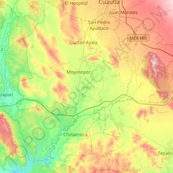
Name: Ayala topographic map, elevation, terrain.

Location: Ayala, Morelos, Mexico (18.56417 -99.09465 18.83093 -98.83578)

Average elevation: 3,970 ft

Minimum elevation: 2,822 ft

Maximum elevation: 5,627 ft

Other topographic maps

Click on a map to view its topography, its elevation and its terrain.

San Pedro Apatlaco

Mexico > Morelos > Ayala

Average elevation: 4,183 ft

Anenecuilco

Mexico > Morelos > Ayala

Average elevation: 4,144 ft

Gear up for your next adventure:

🥩Freeze-Dried Meals - Nutritious and lightweight food for remote expeditions
🔌Solar Panel Charger - Charge gear sustainably outdoors
🔥Camping Stove - Portable stove for camping and backcountry cooking
📡GPS Antenna Upgrade - Enhance GPS reception in remote terrain
🔦Compact Flashlight - Reliable flashlight for emergencies

As an Amazon Associate, this site earns from qualifying purchases at no extra cost to you.