
Make a donation
Gear up for your next adventure:
As an Amazon Associate, this site earns from qualifying purchases at no extra cost to you.
Barão Geraldo topographic map
Click on the map to display elevation.
Make a donation
Gear up for your next adventure:
As an Amazon Associate, this site earns from qualifying purchases at no extra cost to you.
About this map
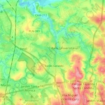
Name: Barão Geraldo topographic map, elevation, terrain.
Average elevation: 2,008 ft
Minimum elevation: 1,804 ft
Maximum elevation: 2,333 ft
Make a donation
Gear up for your next adventure:
As an Amazon Associate, this site earns from qualifying purchases at no extra cost to you.
Other topographic maps
Click on a map to view its topography, its elevation and its terrain.
MAAS(Museu Aberto de Astronomia)
Brasil > São Paulo > Região Metropolitana de Campinas > Campinas
Average elevation: 3,081 ft
Esmeralda Ville
Brasil > São Paulo > Região Metropolitana de Campinas > Campinas
Average elevation: 2,316 ft
Praça Arautos da Paz
Brasil > São Paulo > Região Metropolitana de Campinas > Campinas
Average elevation: 2,162 ft
Pedreira do Chapadão
Brasil > São Paulo > Região Metropolitana de Campinas > Campinas
Average elevation: 2,244 ft
Make a donation
Gear up for your next adventure:
As an Amazon Associate, this site earns from qualifying purchases at no extra cost to you.
Córrego da Lagoa
Brasil > São Paulo > Região Metropolitana de Campinas > Campinas
Average elevation: 1,978 ft
Campo Grande
Brasil > São Paulo > Região Metropolitana de Campinas > Campinas
Average elevation: 1,972 ft
Barão Geraldo
Brasil > São Paulo > Região Metropolitana de Campinas > Campinas
Average elevation: 2,005 ft
Praça Euclides da Cunha
Brasil > São Paulo > Região Metropolitana de Campinas > Campinas
Average elevation: 2,247 ft
Make a donation
Gear up for your next adventure:
As an Amazon Associate, this site earns from qualifying purchases at no extra cost to you.
Lagoa Isaura Teles Alves de Lima
Brasil > São Paulo > Região Metropolitana de Campinas > Campinas
Average elevation: 2,178 ft
Parque das Águas
Brasil > São Paulo > Região Metropolitana de Campinas > Campinas
Average elevation: 2,316 ft