
Make a donation
Gear up for your next adventure:
As an Amazon Associate, this site earns from qualifying purchases at no extra cost to you.
Praça Euclides da Cunha topographic map
Click on the map to display elevation.
Make a donation
Gear up for your next adventure:
As an Amazon Associate, this site earns from qualifying purchases at no extra cost to you.
About this map
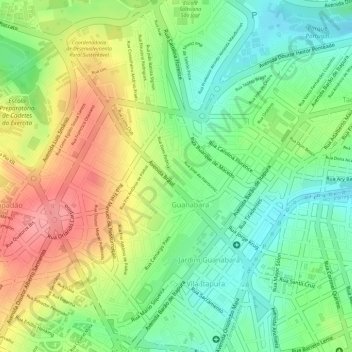
Name: Praça Euclides da Cunha topographic map, elevation, terrain.
Average elevation: 2,247 ft
Minimum elevation: 2,093 ft
Maximum elevation: 2,428 ft
Make a donation
Gear up for your next adventure:
As an Amazon Associate, this site earns from qualifying purchases at no extra cost to you.
Other topographic maps
Click on a map to view its topography, its elevation and its terrain.
Joaquim Egídio
Brasil > São Paulo > Região Metropolitana de Campinas > Campinas
Average elevation: 2,536 ft
Barão Geraldo
Brasil > São Paulo > Região Metropolitana de Campinas > Campinas
Average elevation: 2,008 ft
Campo Grande
Brasil > São Paulo > Região Metropolitana de Campinas > Campinas
Average elevation: 1,972 ft
Make a donation
Gear up for your next adventure:
As an Amazon Associate, this site earns from qualifying purchases at no extra cost to you.
Ouro Verde
Brasil > São Paulo > Região Metropolitana de Campinas > Campinas
Average elevation: 2,047 ft
Barão Geraldo
Brasil > São Paulo > Região Metropolitana de Campinas > Campinas
Average elevation: 2,005 ft
Campo Grande
Brasil > São Paulo > Região Metropolitana de Campinas > Campinas
Average elevation: 2,001 ft
Mata de Santa Genebra
Brasil > São Paulo > Região Metropolitana de Campinas > Campinas
Average elevation: 2,001 ft
Make a donation
Gear up for your next adventure:
As an Amazon Associate, this site earns from qualifying purchases at no extra cost to you.
Ouro Verde
Brasil > São Paulo > Região Metropolitana de Campinas > Campinas
Average elevation: 2,047 ft