
Traverse City topographic map
Click on the map to display elevation.
Traverse City
The locale and topography is conducive for road bicycling, aided by the TART trail system. A map with routes, different trips, advice and local knowledge is available. Lake Michigan presents a location for sailing, fishing, and kayaking.
About this map
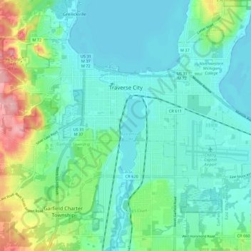
Name: Traverse City topographic map, elevation, terrain.
Average elevation: 669 ft
Minimum elevation: 571 ft
Maximum elevation: 1,007 ft
Grand Traverse County trails, hiking, mountain biking, running and outdoor activities
Other topographic maps
Click on a map to view its topography, its elevation and its terrain.
Old Mission
United States > Michigan > Grand Traverse County
Old Mission is located just east of M-37 near the tip of Old Mission Peninsula about 16 miles (25.75 km) north of Traverse City. The community was built along Old Mission Harbor, which is a small safe haven along the East Arm of Grand Traverse Bay. The community sits at an elevation of 587 feet (179 m) above…
Average elevation: 623 ft
Lookout Point
United States > Michigan > Grand Traverse County > Peninsula Township
Average elevation: 617 ft
Diamond Park
United States > Michigan > Grand Traverse County > Green Lake Township
Average elevation: 837 ft